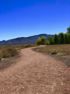
Egan Crest Trail System The Egan Crest Trail System provides recreationists with 24 miles of trails with a variety of terrain from the rolling sagebrush flats to the higher elevations in pinyon and juniper forests.
The trails consist of single-track and signed two-track roads and are open to hiking, mountain biking, equestrian, motorcycles, and ATVs.
Beautiful vistas await along the high points of the trail. Things to note: 2 trail loops and 2 connector trails: 24 miles total / 38.6 km. Other amenities:
Picnic tables and shade structures at trailhead. No potable water!!!
Latitude / Longitude 39.3464, -115.032
At this time, there are no use fees.
Directions The BLM trailhead is approximately 8 miles west of Ely off Highway 50 on the north side of the road.
Pictures below are provided by contributors or supporters of this website. If you are interested in sharing your pictures of Nevada, please drop us a note.
Courtesy S. Ward – Nature trails, Paranghat Wildlife Refuge